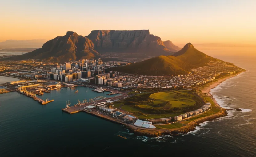
 Cape Town · AI city illustration · Artistic impression
City · Africa
Cape Town
Also known as Kaapstad, iKapa
Saved in this browser — no account needed. Sign in later and it comes with you.
Read its story
Where it is
Cape Town sits between Table Mountain and Table Bay, on a narrow strip between mountain and sea at the north end of the Cape Peninsula. The mountain shapes almost everything about the city: it blocks expansion, catches the rain that made a supply station viable, and divides the wealthy Atlantic-facing suburbs from the Cape Flats, the low sandy plain to the east where apartheid's forced removals sent most of the population.
The land and water around it
Table Mountainmountains
A flat-topped sandstone massif rising directly behind the city. It constrains the built area, generates the orographic cloud locals call the tablecloth, and its slopes hold fynbos found nowhere else.
The Cape Flatsbasin
Low, sandy, wind-exposed ground east of the mountain, and where forced removals relocated most of the city's population. Distance from work and from the centre was a feature of the policy, not a side effect.
Table Baygulf
The anchorage the settlement was placed for. Exposed to north-westerly winter storms, which is why False Bay on the peninsula's other side was used seasonally.
Its history, in short
The Dutch East India Company established a refreshment station at Table Bay in 1652 to supply ships rounding the Cape. Farming, land seizure from Khoikhoi pastoralists and the importation of enslaved people from Africa, South and Southeast Asia followed within a generation. Britain took the Cape during the Napoleonic wars. In the twentieth century the Group Areas Act rewrote the city by law: districts were assigned to racial categories and people living in the wrong one were removed — most visibly from District Six, declared white in 1966 and largely demolished. The spatial pattern that produced has outlasted the law by decades.
Timeline
Dates are shown on a timeline rather than as changing shapes on the map. The globe draws modern boundaries only, and tinting a modern outline to stand for a historical one would state something we cannot source.
Early modern & oceanic
1652
A refreshment station
The Dutch East India Company establishes a supply post at Table Bay. The intention is not a colony; farms, land seizure and imported enslaved labour follow within years.
Well attestedUNESCO World Heritage Centre1795–1806
Britain takes the Cape
Control passes to Britain during the Napoleonic wars, briefly returns to Dutch rule, and is taken again in 1806.
Well attestedUNESCO World Heritage Centre
Industrial & imperial
1834
Emancipation at the Cape
Slavery is abolished across the British Empire, ending a labour system that had operated at the Cape for nearly two centuries. Emancipation Day is still marked in the city.
Well attestedUNESCO World Heritage Centre
Contemporary
1966–1982
District Six
An inner-city neighbourhood is declared white under the Group Areas Act. Tens of thousands of residents are forcibly removed and the buildings largely demolished. The land stood conspicuously empty for decades; restitution claims are still being worked through.
Well attestedUNESCO World Heritage Centre11 February 1990
Mandela speaks from the City Hall balcony
Released after twenty-seven years, eighteen of them on Robben Island in the bay, Nelson Mandela addresses a crowd on the Grand Parade hours after leaving prison.
Well attestedUNESCO World Heritage Centre2017–2018
Day Zero
A severe multi-year drought brings the city close to shutting off municipal supply. Consumption roughly halved through restrictions, tariffs and public campaigning, and the date kept receding until the rains returned.
Well attestedUNESCO World Heritage Centre
Places that carry meaning
Robben Island17th century onward
Visible from the waterfront. A place of banishment for centuries and a maximum-security political prison under apartheid; now a museum, with former prisoners among its guides.
District Six19th century – 1982
The removed neighbourhood. Its museum is run substantially by former residents, and what stands on the land is still being decided.
Bo-Kaap18th century onward
A quarter historically associated with Cape Malay families descended from people enslaved and exiled from Southeast Asia. Its painted houses are widely photographed; its residents are contending with rapid gentrification.
Languages here
Places are usually multilingual. This lists what is actually spoken, not one language per border.
AfrikaansGermanic family
One of the city's most widely spoken first languages.
Formed at the Cape from Dutch in contact with Khoikhoi, Malay and the languages of enslaved people. Most first-language speakers nationally are coloured South Africans; the language's use as an instrument of apartheid policy has complicated that ever since.
isiXhosaBantu family
Widely spoken across the city, particularly in the townships of the Cape Flats.
One of South Africa's largest languages by speakers, and one of the country's twelve official languages.
EnglishGermanic family
The language of business, higher education and much public life.
A first language for a minority and a working language for many more, which is a common pattern in multilingual states and frequently mistaken for dominance in the home.
Learn the language here
- 1Understand which languages are spoken hereCape Town is multilingual. Start with which languages are used, by whom, and for what — the phrase list only covers one of them.Written by Globe Quest
- 2Learn 12 phrasesCurated everyday phrases for Cape Town, with audio and a written form.Written by Globe Quest
- 3Say them out loudSpeaking practice with pronunciation feedback, one phrase at a time.Globe Quest material, your own additions
- 4Come back to themSpaced review, so what you learned this week is still there next month.Written by Globe Quest
- 5Read why the language is what it isThe quest for this place covers how its languages got here and who speaks them.Written by Globe Quest
Check yourself
Why was a settlement placed at Table Bay in 1652?
To supply ships rounding the Cape with water and food
A refreshment station on somebody else's shipping route. The colony was not the stated plan.
What made the District Six removals possible?
Legislation assigning urban areas to racial categories
The Group Areas Act reclassified the district and provided the machinery for forced removal.
Worth arguing about
- Apartheid's spatial pattern has outlasted the law by decades. What would actually undo it?
- Day Zero was avoided by halving consumption. What does that suggest about how much demand is fixed?
What we have not established
These are open questions, listed rather than filled in. We would rather show a gap than a plausible guess.
How many people were removed from District Six?
Figures around sixty thousand are commonly given, but the removals ran over more than fifteen years and counts differ on whether they include people who left in anticipation. The District Six Museum and land-claim records are the right sources; we have not fixed one we can cite and re-check.
Sources
- UNESCO · Robben IslandUNESCO World Heritage Centre · intergovernmental · checked 2026-09-08
- UNESCO · Cape Floral Region Protected AreasUNESCO World Heritage Centre · intergovernmental · checked 2026-09-08
Reviewed by Globe Quest editorial on 2026-09-08.